VDatum User Guide
This User Guide describes VDatum version 4.x with the graphical user interface.
Once you download VDatum software and its transformation grids, your computer is ready to transform geospatial data among several horizontal and vertical datums.
Step-by-step
-
 Step 1: Launch VDatum software
If you are going to convert data from or to a tidal datum, you will need the tidal transformation grids of your area of interest.
Follow steps below for transforming elevation data or seeing these steps in an animated tutorial, available here.
-
Step 2: Define georeferencing information:
What is your data's horizontal datum, coordinate system? What is its vertical datum? How would you like to georeference your data in? etc.. Deselect the Vertical datum information to do 2-D transform (i.e. horizontal transform only).
-
Step 3: Define input data to convert:
Launch VDatum
To run from Window Explorer, locate the VDatum.bat file and double click on that file.
When launched, an MS-DOS command window and the VDatum application window are opened. The MS-DOS command window is where information such as Disclaimer and error messages are displayed. All activity is done with the VDatum application window.
To run VDatum tool from the command prompt or terminals, type the following:
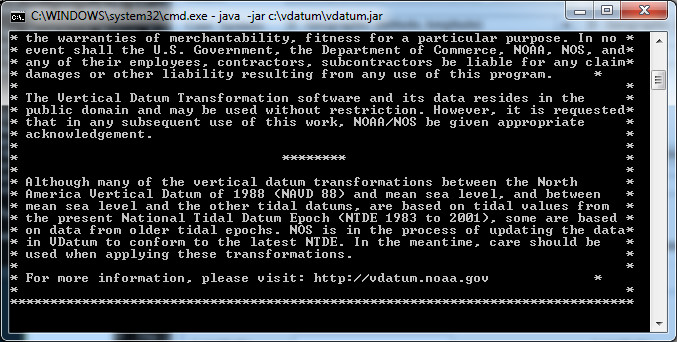
Figure 1: the MS-DOS command window where Disclaimer and error messages are displayed.
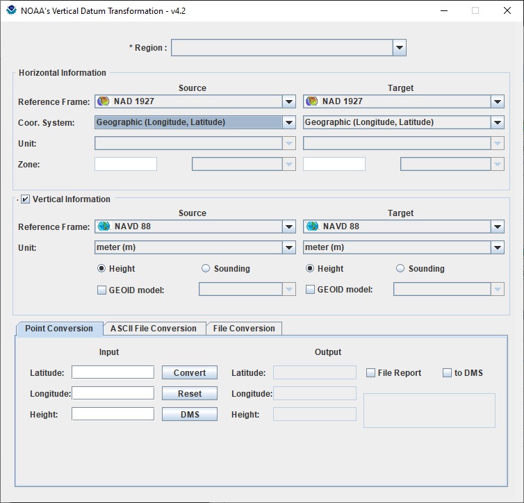
Figure 2: the VDatum app GUI
Define georeferencing information
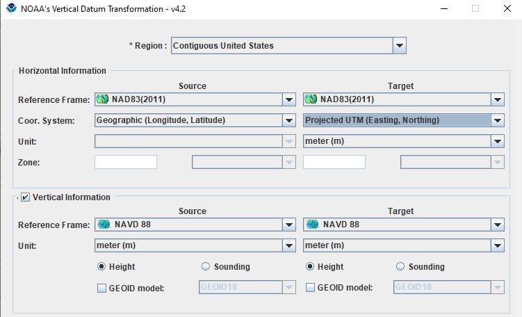
Figure 3: Datum Information
- To convert to State Plane Coordinate system, target SPC zone must be specified.
- A GEOID model is needed to convert from or to an ellipsoidal datum (NAD83, WGS84, ITRFxx). If not specified, the newest available GEOID model will be used.
Point Conversion
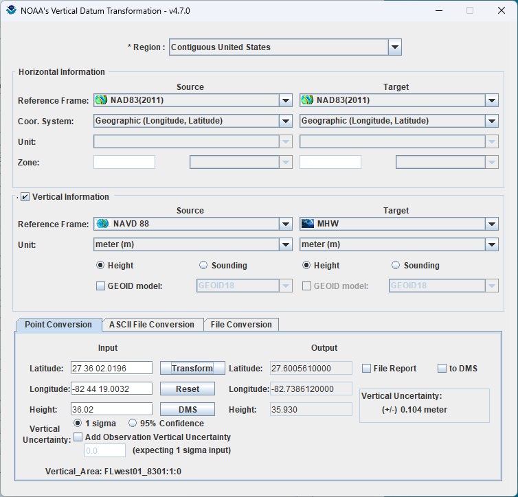
Figure 4: Input data as an elevation point in geographic coordinate
Input data in geographic coordinate system (Latitude/Longitude) are accepted in formats listed below:
- Decimal degree (dd.dddd): for example 27.614899 or -77.62667
- Degrees and decimal minutes separated by blanks (dd mm.mmmm): for example 27 36.87987 or -77 37.6
- Degrees, minutes, and decimal seconds separated by blanks (dd mm ss.ssss): for example -77 37 26.0
- Longitude must be in [-180..180] where west longitudes are negative
When select File Report, a report will be created and saved at user's specified location. Output coordinates can be converted between decimal degrees and DMS (degree minute second) format on-screen by clicking the DMS button, or in file report by selecting "to DMS". A sample report can be viewed at sample_pointreport.txt.
ASCII File Conversion
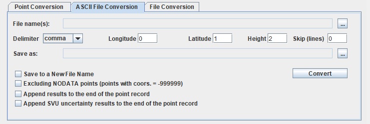
Figure 5: Convert a text file - this sample file is available for download here
Input file(s): Press the button
 for locating input file(s).
Input files shall share the same georeferencing information. Data sets of mixed characteristics must be broken into subsets with common characteristics prior to processing with VDatum.
-
File Format: ASCII, text file: in plain-text form of multiple lines, separated by line breaks. Each line is a point record containing coordinates and/or other information of a point. Each record consists of fields, separated by a delimiter such as comma, tab, semi-colon or space. All records shall have an identical sequence of fields. Field index starts from 0.
If input file(s) contain header lines, assign the number of these lines in the Skip (lines) box. Otherwise, output file(s) might contain header lines as -999999.0,-999999.0,-999999.0.
For example: a point record of [-68 24 30.5779477419, 44 15 49.1923986516, 12.7704, BP1042] shall be set up as:
- longitude field index = 0 (longitude = -68 24 30.5779477419),
- latitude field index = 1 (latitude = 44 15 49.1923986516)
- height field index = 2 (if height = 12.7704) or height field index = N/A if height is not available.
Output file/folder:
If there is only one input file, a user could press the button
for choosing an output file. By default, output files will be stored in a sub folder name result and have the same name as the source files.There is also a log file for each converted file that includes georeferencing information of the file, number of converted points and more.
- Select optional functions such as Excluding NODATA points or Appending results to the end of the point record.
- Press Convert to transform.
A window shows converting progress in percentages. Users can cancel the processing anytime by pressing the Cancel button.
LiDAR (.LAS/.LAZ) Conversion
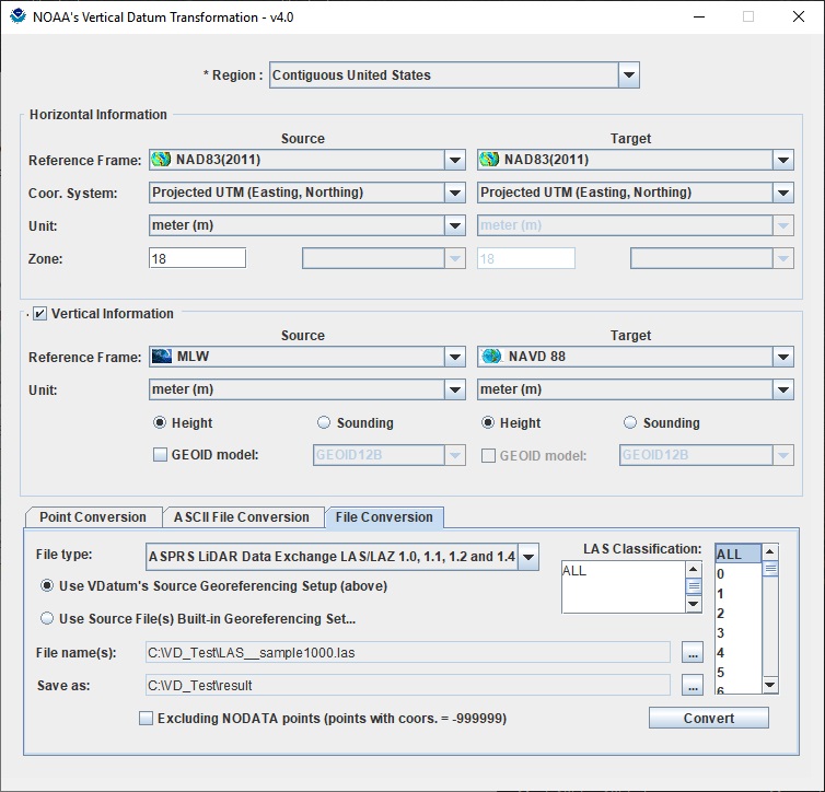
Figure 6: Convert a LiDAR (*.LAS) file - a sample LAS file is available here.
-
File Type: LiDAR (*.las or *.laz) version 1.0, 1.1, 1.2 or 1.4
Input file(s): Press the button
for locating input file(s).VDatum automatically detects the georeferencing information of each LAS file when converting. If georeferencing information is detected, these information will be displayed and Use Source File(s) Built-in Georeferencing Setup is selected. When converting multiple files, only georeferencing information of the first LAS file in the list will be displayed. If Use Source File(s) Built-in Georeferencing Setup is selected for multiple files, VDatum will automatically get the georeferencing information of each input file.
We recommend that users check these information and set manually by selecting Use VDatum's Source Georeferencing Setup (above). When this button is selected, all input files (when converting multiple files) will be considered as georeferenced with the VDatum's Source setup information.
Output file/folder:
If there is only one input file, a user could press the button
for choosing an output file. By default, output files will be stored in a sub folder name result and have the same name as the source files.There also a log file for each converted file that includes georeferencing information of the file, number of converted points and more.
- Press Convert to transform.
A window shows converting progress in percentages. Users can cancel the processing anytime by pressing the Cancel button.
For .LAZ formtat file, it can only be processed in VDatum app on Windows OS
SHAPEFILE (.SHP) Conversion
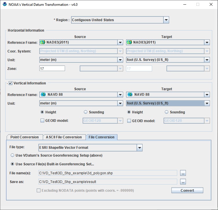
Figure 8: Convert a SHAPEFILE (*.shp) file - a sample SHAPEFILE file is available here.
-
File Type: SHAPEFILE (*.shp)
Input file(s): Press the button
for locating input file(s).VDatum automatically detects the georeferencing information of each SHAPEFILE file when converting. If georeferencing information is detected, these information will be displayed and Use Source File(s) Built-in Georeferencing Setup is selected. When converting multiple files, only georeferencing information of the first LAS file in the list will be displayed. If Use Source File(s) Built-in Georeferencing Setup is selected for multiple files, VDatum will automatically get the georeferencing information of each input file.
We recommend that users check these information and set manually by selecting Use VDatum's Source Georeferencing Setup (above). When this button is selected, all input files (when converting multiple files) will be considered as georeferenced with the VDatum's Source setup information.
Output file/folder:
If there is only one input file, a user could press the button
for choosing an output file. By default, output files will be stored in a sub folder name result and have the same name as the source files.There also a log file for each converted file that includes georeferencing information of the file, number of converted points and more.
- Press Convert to transform.
A window shows converting progress in percentages. Users can cancel the processing anytime by pressing the Cancel button.
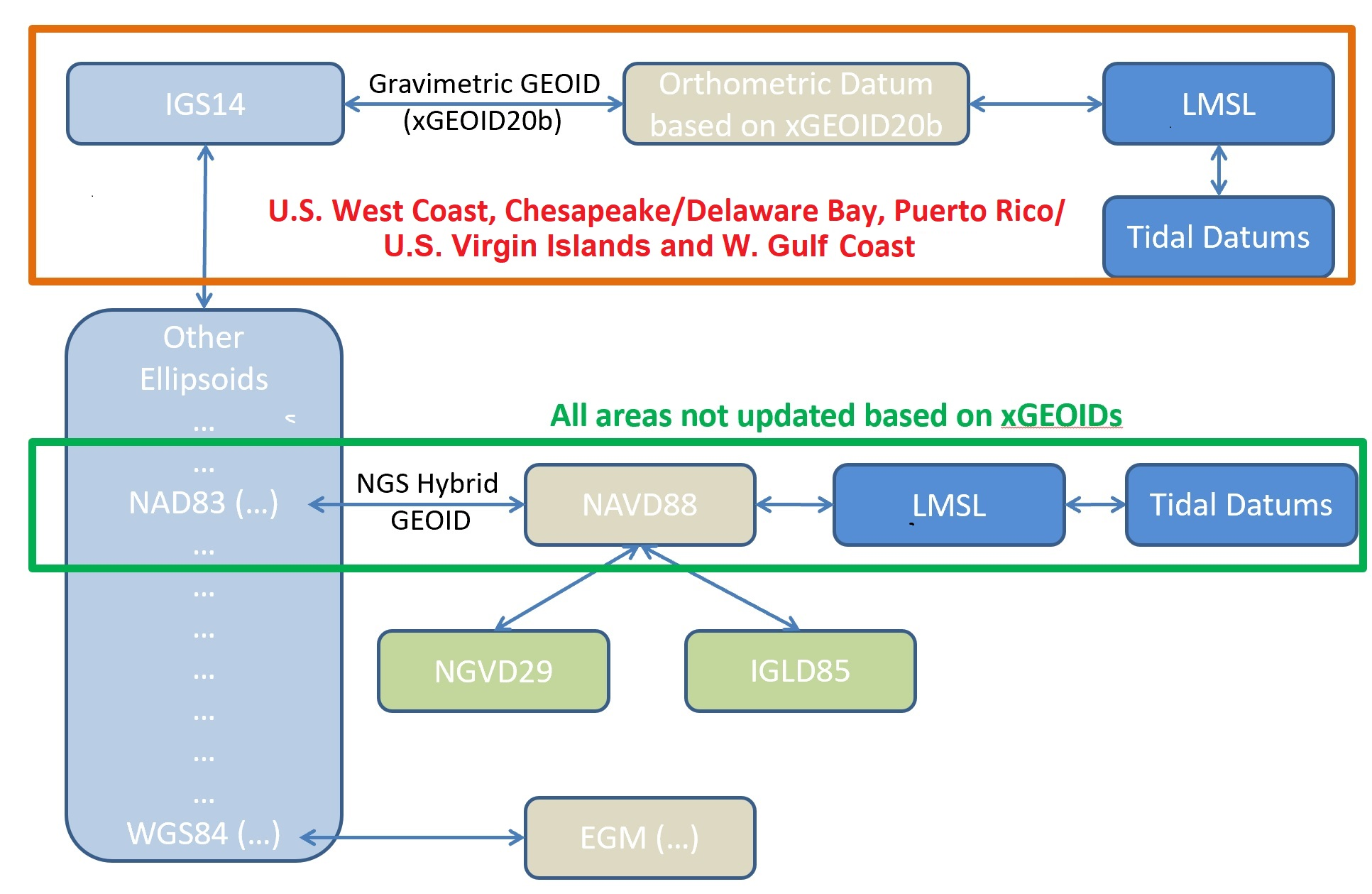
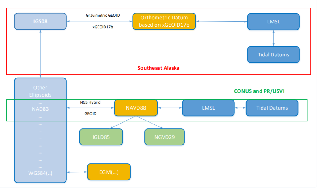
SE Alaska
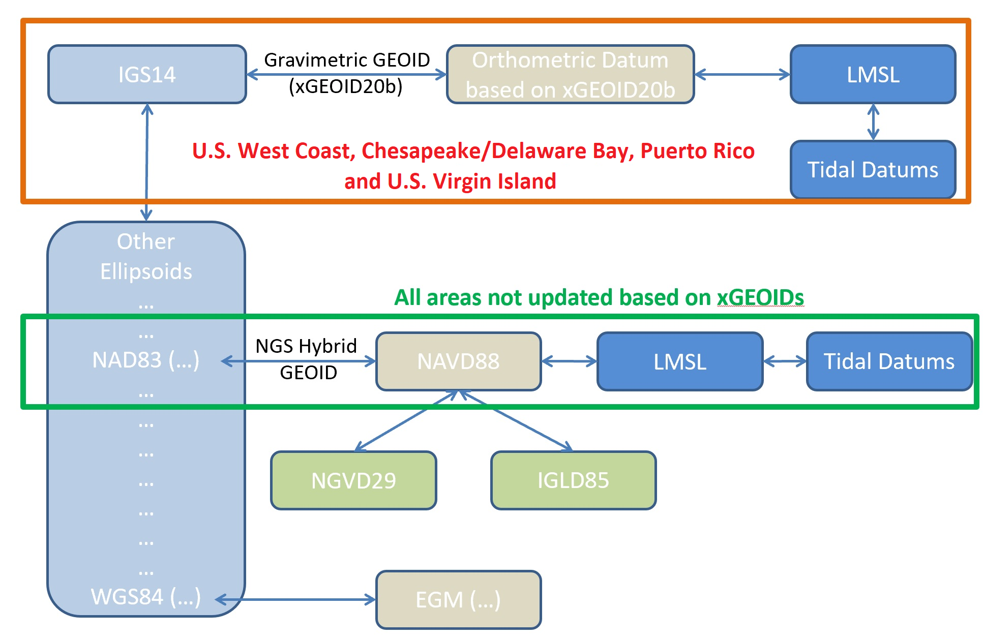
When transforming in the Southeast Alaska regional model and traversing to Local Mean Sea Level (LMSL) or other Tidal Datums, it is important to understand the transformation roadmap differs from that of other currently supported VDatum regional models. You will notice that the Target Horizontal reference frame automatically changes to IGS08 when selecting LMSL or a Tidal Datum as the source or target vertical datum while in Alaska. The reason for this is that our roadmap traverses through IGS08, then utilizes xGEOID17B, and then into LMSL with the Topography of the Sea Surface (TSS) and then to tidal datums. All other VDatum regional models traverse through NAD83 and then to NAVD88 utilizing a NGS Hybrid GEOID.
Sample Scenario:
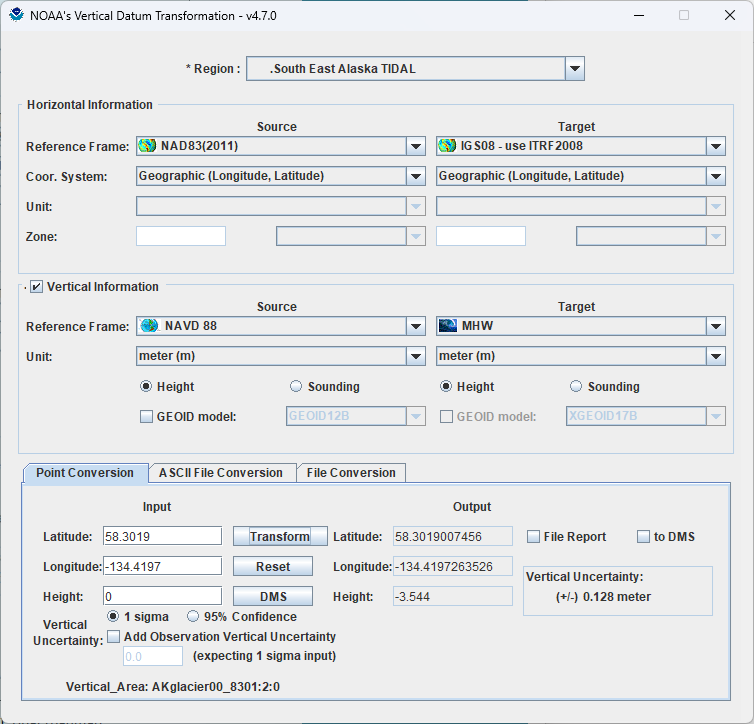
SEAK Tidal Vertical Datum Transformation “Roadmap” shows the difference from CONUS & PR/USVI Tidal roadmap.
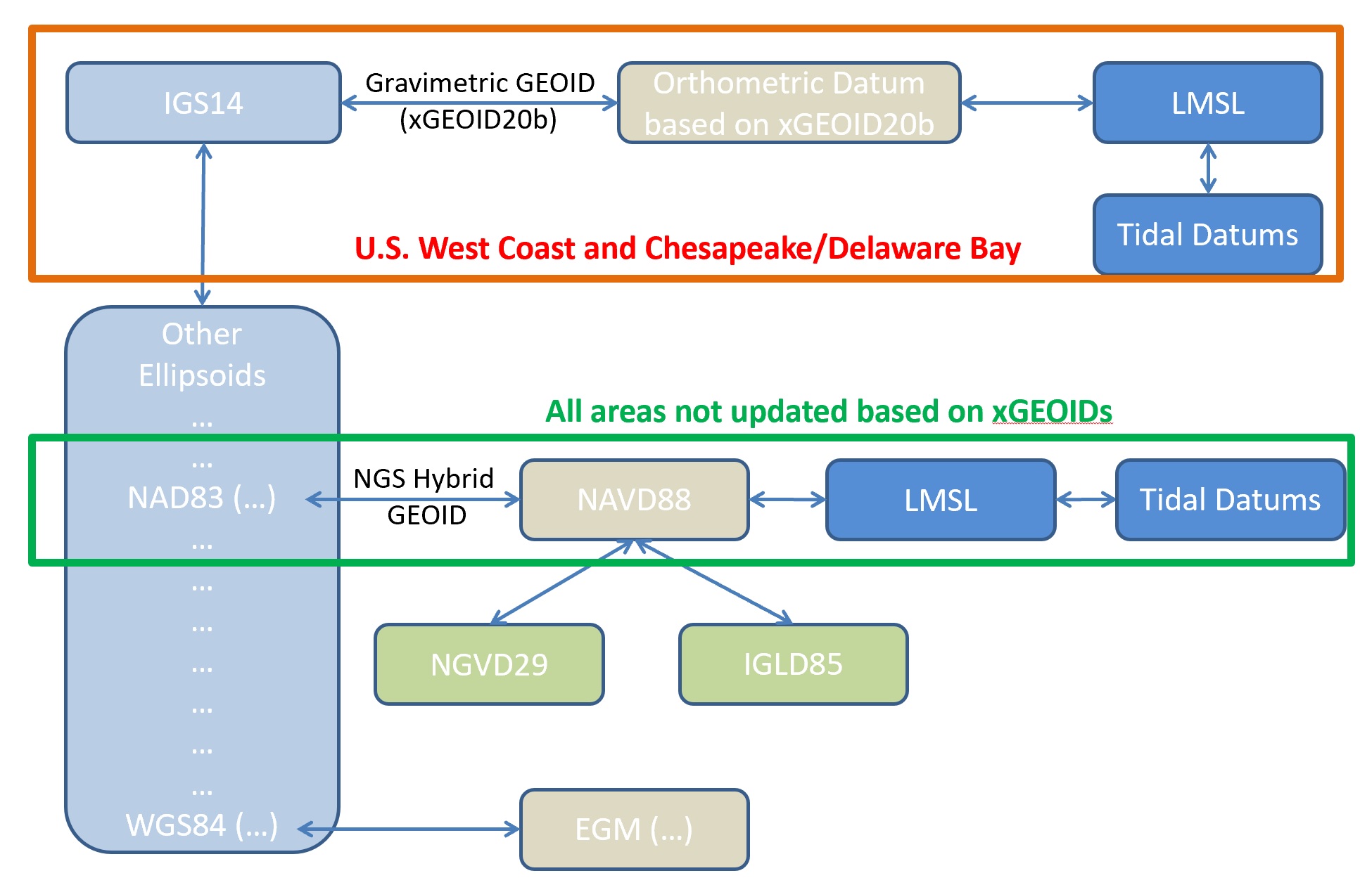
Chesapeake/Delaware Bays and Mid-Atlantic Bight
When transforming in the Chesapeake/Delaware regional model and traversing to Local Mean Sea Level (LMSL) or other Tidal Datums, it is important to understand the transformation roadmap differs from that of other currently supported VDatum regional models. You will notice that the Target Horizontal reference frame automatically changes to IGS14 when selecting LMSL or a Tidal Datum as the source or target vertical datum while in Chesapeake/Delaware Bay vicinity. The reason for this is that our roadmap traverses through IGS14, then utilizes xGEOID20B, and then into LMSL with the Topography of the Sea Surface (TSS) and then to tidal datums. All other VDatum regional models traverse through NAD83 and then to NAVD88 utilizing a NGS Hybrid GEOID, except Southeast Alaska which uses IGS08, then utilizes xGEOID17b. The use of xGEOID's is to assist in preparation for transitioning to the modernized National Spatial Reference System (NSRS) in the future.
Sample Scenario:
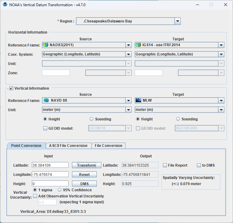
Chesapeake/Delaware Bay Tidal Vertical Datum Transformation “Roadmap” shows the difference from CONUS & PR/USVI Tidal roadmap.
West Coast
When transforming in the West Coast regional model and traversing to Local Mean Sea Level (LMSL) or other Tidal Datums, it is important to understand the transformation roadmap differs from that of other currently supported VDatum regional models. You will notice that the Target Horizontal reference frame automatically changes to IGS14 when selecting LMSL or a Tidal Datum as the source or target vertical datum while in West Coast vicinity. The reason for this is that our roadmap traverses through IGS14, then utilizes xGEOID20B, and then into LMSL with the Topography of the Sea Surface (TSS) and then to tidal datums. All other VDatum regional models traverse through NAD83 and then to NAVD88 utilizing a NGS Hybrid GEOID, except Southeast Alaska which uses IGS08, then utilizes xGEOID17b. The use of xGEOID's is to assist in preparation for transitioning to the modernized National Spatial Reference System (NSRS) in the future.
Sample Scenario:
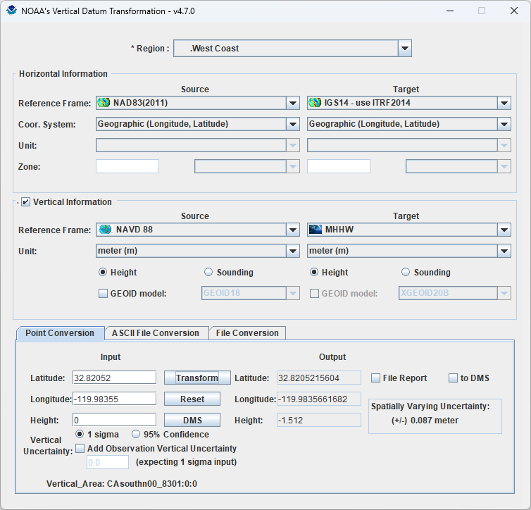
West Coast Tidal Vertical Datum Transformation “Roadmap” shows the difference from CONUS & PR/USVI Tidal roadmap.
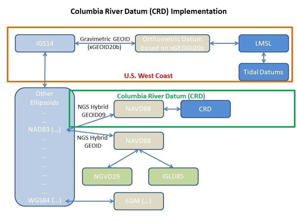
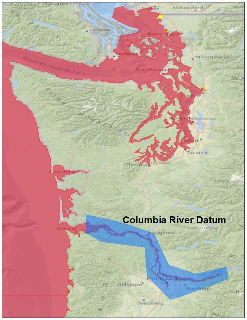
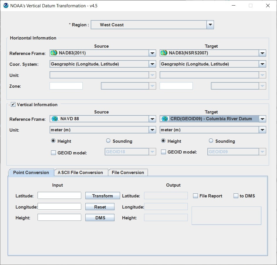
Columbia River Datum
The Columbia River Datum (CRD) is being implemented based on the grid provided by the U.S. Army Corps of Engineers (USACE). This transformation is based on utilizing GEOID09 to transform to NAVD88 and then to CRD. GEOID09 was the hybrid National Geodetic Survey (NGS) GEOID utilized for the CRD grid development.
The Columbia River Datum (CRD) is the adopted fixed low water reference plane for this area. CRD is a U.S. Army Corps of Engineers non-tidal datum defined at distinct river miles relative to NAVD88, and is used as chart datum above river mile 23 on the Columbia River. Datums are computed using observations from the low river stages of the year, generally August through October due to the masking of the tidal signal from strong seasonal river runoff during other portions of the year. Depending on river flow, water levels can be significantly higher than Columbia River Datum.
Initial testing of the implementation of CRD in VDatum provides us with some insight to the uncertainty of these transforms. The VDatum implementation was tested against Center for Operational Oceanographic Products and Services (CO-OPS) published data at the following stations:
- Skamokawa
- Wauna
- Longview
- St. Helens
- Vancouver
Tidal Datums relative to CRD provided differences ranging from 2.5 centimeters at St. Helens to 7.2 centimeters at both Longview and Vancouver. Transforming between tidal datums resulted in differences ranging from a few millimeters to 1.1 centimeter at Longview. Larger uncertainties can be expected between Local Mean Sea Level and NAVD88, due to the transformation roadmap implemented for the West Coast tidal datums, utilizing xGEOID20b and how a user may want to define the transform of NAVD88 based on a particular NGS hybrid GEOID. Uncertainties for transforms between Local Mean Sea Level and NAVD88 of 2-13 centimeters can be expected.
CRD is accessed through the West Coast Regional Model as illustrated below.
Puerto Rico and US Virgin Island
When transforming in the Puerto Rico/U.S. Virgin Islands regional model and traversing to Local Mean Sea Level (LMSL) or other Tidal Datums, it is important to understand the transformation roadmap differs from that of other currently supported VDatum regional models. You will notice that the Target Horizontal reference frame automatically changes to IGS14 when selecting LMSL or a Tidal Datum as the source or target vertical datum while in Puerto Rico/U.S. Virgin Islands vicinity. The reason for this is that our roadmap traverses through IGS14, then utilizes xGEOID20B, and then into LMSL with the Topography of the Sea Surface (TSS) and then to tidal datums. This is similar to the current implementations of Chesapeake/Deleware Bay and West Coast regional models. All other VDatum regional models traverse through NAD83 and then to NAVD88 utilizing a NGS Hybrid GEOID, except Southeast Alaska which uses IGS08, then utilizes xGEOID17b. The use of xGEOID's is to assist in preparation for transitioning to the modernized National Spatial Reference System (NSRS) in the future.
Sample Scenario:
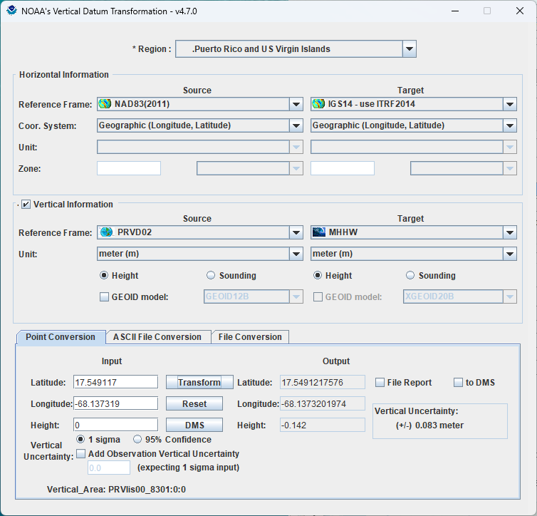
PRVI Tidal Vertical Datum Transformation “Roadmap” shows the difference from CONUS Tidal roadmap.
Western Gulf Coast
When transforming in the Western Gulf Coast regional model and traversing to Local Mean Sea Level (LMSL) or other Tidal Datums, it is important to understand the transformation roadmap differs from that of other currently supported VDatum regional models. You will notice that the Target Horizontal reference frame automatically changes to IGS14 when selecting LMSL or a Tidal Datum as the source or target vertical datum while in the Western Gulf Coast vicinity. The reason for this is that our roadmap traverses through IGS14, then utilizes xGEOID20B, and then into LMSL with the Topography of the Sea Surface (TSS) and then to tidal datums. This is similar to the current implementations of Chesapeake/Deleware Bay, West Coast, and Puerto Rico/U.S. Virgin Islands regional models. All other VDatum regional models traverse through NAD83 and then to NAVD88 utilizing a NGS Hybrid GEOID, except Southeast Alaska which uses IGS08, then utilizes xGEOID17b. The use of xGEOID's is to assist in preparation for transitioning to the modernized National Spatial Reference System (NSRS) in the future.
Sample Scenario:
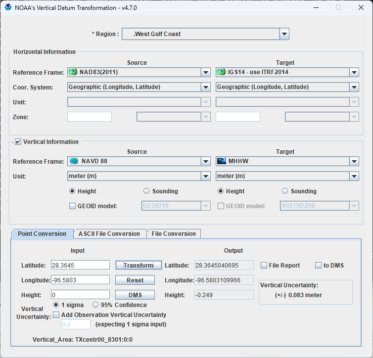
Western Gulf Coast Tidal Vertical Datum Transformation “Roadmap” shows the difference from previous roadmaps utilizing the older NGS Hybrid GEOIDs.