
About VDatum
The coastal land-water interface depends on how water levels change and the land moves vertically in both space and time. To combine or compare coastal elevations (land heights and water depths) from diverse sources, they must be referenced to the same vertical datum in a common framework. Using inconsistent datums can cause artificial discontinuities that become acutely problematic when producing maps at the accuracy that is critically needed by federal, state, and local authorities to make informed decisions.
Integrating our Nation's Elevation Data Efficiently and Accurately
The National Oceanic and Atmospheric Administration (NOAA -//www.noaa.gov/) has developed a revolutionary vertical datum transformation tool (VDatum) to address the inconsistent datum problem. A datum is the reference level to which geospatial data are gathered. For example, in the interest of navigational safety, NOAA collects water depth data to Mean Lower Low Water, and shoreline data to Mean High Water. The U.S. Geological Survey presently has their land elevation data referenced to Mean Sea Level and other datums. Geospatial data collected by NOAA and many other agencies and entities, particularly data collected in coastal regions, suffer from being tied to many different vertical reference datums.
VDatum translates geospatial data between 36 different vertical reference systems and removes the most serious impediments to data sharing allowing for the easy transformation of elevation data from one vertical datum to another. Geospatial data can be seamlessly integrated for the benefit of the U.S. public for applications such as Homeland Security and natural disaster preparedness. VDatum also allows NOAA to make full use of recent technological advancements [such as integration of depth data from an aircraft using a laser (LIDAR)] that will greatly improve the efficiency with which it acquires new and more accurate data for NOAA's nautical, navigational, and geospatial products and services. VDatum will also improve the efficiency and accuracy of hydrographic surveys for nautical charts by eliminating the need for time-consuming water level corrections and post processing.
A Little History
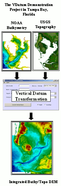
The National Oceanic and Atmospheric Administration (NOAA) and the U.S. Geological Survey (USGS) first addressed the vertical datum transformation issue by collaborating on the pilot project to support a seamless bathymetric - topographic digital elevation model (DEM) for Florida's Tampa Bay region by merging the "best available" NOAA bathymetric data and USGS topography data. The VDatum software originally was designed to accommodate 28 transformations spanning the three major classes of vertical datums: orthometric, ellipsoidal, and tidal. A geoid model was used to convert between orthometric and ellipsoidal datums, a topography of the sea surface was computed to relate orthometric and tidal datums, and tidal modeling was used to compute the tidal datums. The output from each of these models was integrated into the VDatum software and then applied to bathymetry and topography for Tampa Bay. The best available bathymetric data were selected from the NOAA / NOS Hydrographic Survey database. For the Tampa bay region, approximately half of the sounding data collected were referenced to a mean low water (MLW) vertical datum, and the other half to a mean lower low water (MLLW) vertical datum. The best available topographic data were selected from the USGS National Elevation Dataset (NED). The NED dataset is horizontally referenced to NAD83 and vertically referenced to NAVD88. Prior to merging, both dataset were transformed to a common reference coordinate system, both horizontally and vertically, using VDatum.
The successful development and implementation of VDatum in Tampa Bay showed how data could be made more useful to coastal managers and applications. Not only were all existing bathy/topo data integrated into a seamless DEM, but the tool can also be used to transform all future elevation data acquired in the area. Shorelines may be more accurately computed by applying VDatum to LIDAR data. Bathymetry may be more easily referenced to a vertical datum, without installation of temporary tide gauges concurrent to hydrographic survey operations. Furthermore, applications dependent on a seamless land-water DEM are now more accurate, including storm surge modeling, habitat restoration, sea level rise effects, and ecosystem studies. All of the benefits of having VDatum available in an area such as Tampa Bay demonstrated its potential utility in serving as a national backbone for linking and transforming elevation data from a multitude of sources.
Building a national VDatum has since proceeded with applications currently covering the continental United States and Puerto Rico and the U.S. Virgin Islands. VDatum is currently revisiting several regions to update models with improved foundational geodetic and tidal data. A seamless VDatum software will emerge to cover all of the U.S. coastal areas out to 25 nautical miles from land. The availability of VDatum nationwide enables bathymetric, topographic and coastline data to be easily transformed and assembled in a manner that complements dissemination through national databases.
Future Applications
Lidar-derived Shoreline
With the completion of the VDatum tool in our Nation's waters, advancements in the awareness of electronic charting systems and ECDIS for the Electronic Navigational Chart will be possible. Vessels's exact orientation in the water can be accurately determined using Differential GPS. This information can then be incorporated into the charting system along with real-time display of water depths corrected for tides for the entire body of water. Danger areas can be displayed automatically that will adjust depending on the vessels draft and water level as a vessel transits through areas of concern. VDatum will also provide a tool for coastal restoration projects that require high-resolution wetland, bathymetric, and water level inundation maps.