
VDatum Command-line User Guide
This User Guide describes how-to run VDatum version 4.x without the graphical user interface.
Once you download VDatum software and its transformation grids, your computer is ready to transform geospatial data among several horizontal and vertical datums.
General syntax:
-
For running VDatum with the graphical user interface:
[Java_home]java -jar vdatum.jar
lib\java_home\openjdk-11.0.2\bin\java -jar vdatum.jar
-
[Java_home]java -jar vdatum.jar -help
lib\java_home\openjdk-11.0.2\bin\java -jar vdatum.jar -help
-
For converting without GUI:
[Java_home]java -jar VDatum.jar <georeferencing_parameters> [<point_conversion>] [<file_conversion>] region:<region_number>
lib\java_home\openjdk-11.0.2\bin\java -jar vdatum.jar <georeferencing_parameters> [<point_conversion>] [<file_conversion>] region:<region_number>
*Check your local JDK or JRE version and location, then add [Java_home] in front of your command if necessary. In NOAA VDatum package, the OpenJDK-11.0.2_Windows-x64 is bundled.
About Java Home:
-
Default in previous version before v4.0:
java -jar vdatum.jar
-
Default in current package:
lib\java_home\openjdk-11.0.2\bin\java -jar vdatum.jar
-
Oracle JDK-1.8.0 in Program Files directory
C:\Program Files\Java\jdk1.8.0_201\bin\java -jar vdatum.jar
-
Oracle JDK-11.0.3 in Program Files directory
C:\Program Files\Java\jdk-11.0.3\bin\java -jar vdatum.jar
-
Open JDK in Programs directory
X:\Programs\Java\openjdk-11.0.1\bin\java -jar vdatum.jar
*Because the big changes from Oracle, some users may not have Oracle JRE installed on their local system or may have different version and different settings for JRE. These may cause VDatum application some running issue.
Starting from release-4.0, OpenJDK-11.0.2_Windows-x64 is bundled with VDatum full package. The package should work well on all Windows 64bit OS. But if you need to use other version of JRE or need to run VDatum app on other OS, please make sure your JRE is set correctly.
Below are some examples for how to set [java_home] for running VDatum app
Georeferencing Parameters
Syntax:
ihorz:<source horizontal datum>[:<coordinate system>:<unit>:<zone>] [ivert:<source vertical datum>[:<unit>:[<height/sounding>[:<geoid>]]]] ohorz:<target horizontal datum>[:<coordinate system>:<unit>:<zone>] [overt:<target vertical datum>[:<unit>[:<height/sounding>[:<geoid>]]]]
where:
| Parameter | Description |
| ihorz | Provides details about horizontal information of the source data. |
| ivert | Provides details about vertical information of the source data. If omitted, the transform is considered to be 2-dimension. |
| ohorz | Provides details about target horizontal information. If omitted, result will be horizontally referenced in NAD83_2011, geographic coordinates. When specify ohorz:ihorz, results are considered to be horizontally referenced exactly as source. This is especially for LiDAR conversion with source and target data are in State Plane coordinate system. |
| overt | Provides details about vertical information of the target data. If omitted, the transform is considered to be 2-dimension. |
| <coordinate system> | Either geo, utm, spc or xyz, corresponding to geographic coordinates, UTM coordinates, State Plane coordinates or geocentric coordinates. If omitted, the geographic coordinate system with horizontal coordinates in degrees (i.e., geo:deg) are used. |
| <unit> |
|
| <height/sounding> | Either height or sounding. If omitted, height is used when a vertical datum is specified. |
| <zone> |
|
| <geoid> | A GEOID model is needed when converting between orthometric datums (NAVD88, NGVD29) and ellipsoidal datums (NAD83_2011, WGS84 or ITRFxx). If omitted, the newest available GEOID model will be used when required. |
Region Number
Syntax:
| region_number | Region Description |
| 1 | Alaska |
| 2 | South East Alaska TIDAL |
| 3 | American Samoa |
| 4 | Contiguous United States |
| 5 | Chesapeake/Delaware Bay |
| 6 | West Coast |
| 7 | West Gulf Coast |
| 8 | Guam and Commonwealth of Northern Mariana Islands |
| 9 | Hawaii |
| 10 | Puerto Rico and US Virgin Islands |
| 11 | Saint George Island |
| 12 | Saint Paul Island |
| 13 | Saint Lawrence Island |
Point Conversion
Syntax
[Java_home]java -jar vdatum.jar <referencing_parameters> [-deg2dms] [-report] -pt:<lon/east/x>,<lat/north/y>[,<height/z>] [-pt:<lon/east/x>,<lat/north/y>[,<height/z>] [epoch:<x:y>] region:<region_number>
where:
Geographic coordinates (longitude, latitude) must be in decimal degrees. For example: 43.301
Longitude cooridnates must be in [-180.. 180]. West longitudes are negative. For example: -77.62667
-deg2dms: all decimal degrees will be converted to degrees, minutes and decimal seconds
-report: results will be written to a file specified by users
epoch: input and output time epochs of positional coordinates. For example: epoch:2017.0:2017.1
Examples:
-
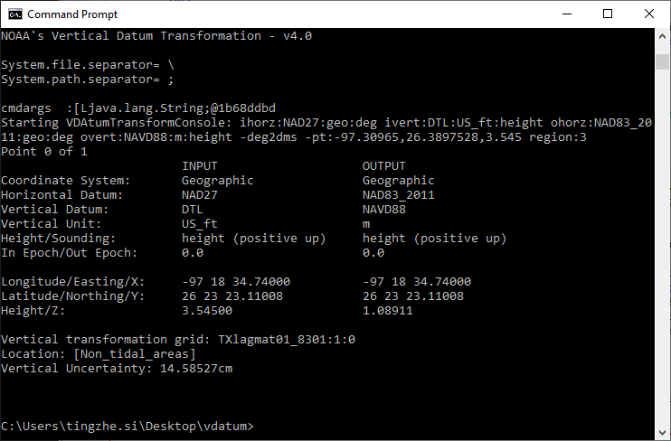
Converts a geographic coordinate point in NAD27 horizontally, DTL height in US Survey foot to NAD83_2011 horizontally and height in NAVD88, meters. Output shall be in degrees, minutes and seconds:
lib\java_home\openjdk-11.0.2\bin\java -jar vdatum.jar ihorz:NAD27:geo:deg ivert:DTL:US_ft:height ohorz:NAD83_2011:geo:deg overt:NAVD88:m:height -deg2dms -pt:-97.30965,26.3897528,3.545 region:4
File Conversion
Syntax
[Java_home]java -jar vdatum.jar <referencing_parameters> [-nodata] -file:<File Format>:<input file #1>[<System.path.separator><input file #i>]<System.path.separator><output folder> [epoch:<x:y>] region:<region_number>
where:
| Parameter | Description |
| -nodata | If specified, all results of -999999 will not be written to the output files. |
| <System.path.separator> | Depends on users' OS system. This could be semi-colon [;] in Windows or colon [:] in Unix/Mac OS. Users could run the help command to get this system information. |
| <File Format> | Either ASCII, LiDAR (LAS) or ESRI ASCII Raster (.ASC) file format. This can't be mixed. |
| epoch | Input and output time epochs of positional coordinates. |
ASCII File Format | |
A plain-text file of multiple lines, separated by line breaks. Each line is a point record containing coordinates and/or other information of a point. Each record consists of fields, separated by a delimiter such as comma, tab, semi-colon or space. All records shall have an identical sequence of fields. Field index starts from 0. Syntax: txt:<coordinate delimitor>,<lon/easting/ECEF-X>,<lat/northing/ECEF-Y>[,<height/ECEF-Z>[,append][,skip<rows>]] where: |
|
| <coordinate delimiter> | A charactor that separates the coordinates on the coordinate lines. Either comma, space, semicolon, or tab. |
| <lon/easting/ECEF-X> | Longitude/Easting/ECEF-X coordinate column order, equal or greater than 0. |
| <lat/northing/ECEF-Y> | Latitude/Northing/ECEF-Y coordinate column order, equal or greater than 0. |
| <height/ECEF-Z> | Elevation column order, equal or greater than 0. |
| -append | If specified, each transform result will be added at the end of each coordinate line. Note: a header line will be automatically generated, displaying the column names. |
| skip<rows> | Number of coordinate lines to skip at the start of the file before trying to extract data. This is useful is some header lines at the start of the file should be skipped over. |
Example: |
File sample: ID,longitude,latitude,elevationH10536,-82.738573,27.602627,35.8102 H10536,-82.738625,27.602763,40.7103 H10536,-82.738678,27.603218,51.2106 H10536,-82.738661,27.603376,54.5107 H10536,-82.738628,27.603687,53.5108 H10536,-82.738620,27.604117,52.5110 H10536,-82.738594,27.604580,51.9112 H10536,-82.738600,27.605044,50.9115 H10536,-82.738633,27.605825,51.2120 Syntax (Windows): [Java_home]java -jar vdatum.jar ihorz:NAD83_2011 ivert:navd88:m:height ohorz:NAD83_2011:geo:deg overt:mllw:m:height -file:txt:space,1,2,3,skip1:<input-file>;<output-folder> region:<region_number> |
LiDAR (.LAS/.LAZ) File Format, version 1.0, 1.1, 1.2 and 1.4 |
|
The LAS file format is a public and binary file format that storing 3-dimensional LiDAR point cloud data. Syntax: las:las[,autosrcgeo] where: |
|
| autosrcgeo | If specified, VDatum will automatically detect the geo-referencing information of the source file(s), stored in the LAS header. |
Example (Windows): [Java_home]java -jar vdatum.jar ihorz:NAD83_2011 ivert:NAVD88 ohorz:ihorz overt:NAD83_2011 -file:las:las,autosrcgeo:<input-file >;<output-folder>
where:
Note that even though the source georeferencing information is specified as "ihorz:NAD83_2011 ivert:NAVD88", these information will be replaced by what extracted from the source file. |
|
asc - ESRI ASCII Raster File Format |
|
Syntax: esri_asc:esri_asc Example (Windows): [Java_home]java -jar vdatum.jar ihorz:NAD83_2011:geo:deg ivert:NAVD88:m:height ohorz:NAD83_2011:geo:deg overt:NAD83_2011:m:height -file:esri_asc:esri_asc:<input-file >;<output-folder> |
|